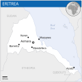
Файл:Eritrea - Location Map (2013) - ERI - UNOCHA.svg

254 × 254 нокта - SVG файлын беренчел карау размеры PNG. Башка ачыклык: 240 × 240 нокта | 480 × 480 нокта | 768 × 768 нокта | 1024 × 1024 нокта | 2048 × 2048 нокта.
Төп файл (SVG файлы, шартлы 254 × 254 нокта, файлның зурлыгы: 262 Кб)
Файл тарихы
Файлның нинди булганлыгын күрү өчен «дата/вакыт» дигәненә басыгыз.
| Дата/вакыт | Кече рәсем | Үлчәмнәре | Кулланучы | Искәрмә | |
|---|---|---|---|---|---|
| агымдагы | 29 дек 2022, 02:52 |  | 254 × 254 (262 Кб) | Wikijahnn | File uploaded using svgtranslate tool (https://svgtranslate.toolforge.org/). Added translation for ca. |
| 18 ноя 2014, 23:54 |  | 254 × 254 (263 Кб) | Pharos | try without logo for now | |
| 18 ноя 2014, 03:12 |  | 254 × 254 (302 Кб) | Pharos | try without logo for now | |
| 21 апр 2014, 00:28 |  | 254 × 254 (302 Кб) | UN OCHA maps bot | == {{int:filedesc}} == {{Information |description={{en|1=Locator map of Eritrea.}} |date=2013 |source={{en|1=[http://reliefweb.int/map/eritrea/eritrea-location-map-2013 Eritrea Locator Map (ReliefWeb)]}} |author={{en|1=[[w:en:United Na... |
Файлны куллану
Әлеге файл киләсе битне куллана:
Файлның гомуми кулланышы
Әлеге файл аста бирелгән викиларда куллана:
- ann.wikipedia.org проектында куллану
- arz.wikipedia.org проектында куллану
- ast.wikipedia.org проектында куллану
- bh.wikipedia.org проектында куллану
- ca.wikipedia.org проектында куллану
- ckb.wikipedia.org проектында куллану
- dag.wikipedia.org проектында куллану
- de.wikivoyage.org проектында куллану
- diq.wikipedia.org проектында куллану
- en.wikipedia.org проектында куллану
- eo.wikinews.org проектында куллану
- es.wikipedia.org проектында куллану
- ff.wikipedia.org проектында куллану
- fr.wikinews.org проектында куллану
- fr.wikivoyage.org проектында куллану
- ga.wikipedia.org проектында куллану
- gd.wikipedia.org проектында куллану
- gl.wikipedia.org проектында куллану
- gpe.wikipedia.org проектында куллану
- gur.wikipedia.org проектында куллану
- ha.wikipedia.org проектында куллану
- he.wikivoyage.org проектында куллану
- ht.wikipedia.org проектында куллану
- ia.wikipedia.org проектында куллану
- id.wikipedia.org проектында куллану
- ig.wikipedia.org проектында куллану
- ilo.wikipedia.org проектында куллану
- incubator.wikimedia.org проектында куллану
- it.wikipedia.org проектында куллану
- ja.wikipedia.org проектында куллану
- kab.wikipedia.org проектында куллану
- lb.wikipedia.org проектында куллану
- lfn.wikipedia.org проектында куллану
- lo.wikipedia.org проектында куллану
- mdf.wikipedia.org проектында куллану
- mg.wikipedia.org проектында куллану
- mt.wikipedia.org проектында куллану
- pl.wikipedia.org проектында куллану
- rm.wikipedia.org проектында куллану
- ro.wikipedia.org проектында куллану
- sco.wikipedia.org проектында куллану
- sd.wikipedia.org проектында куллану
- shi.wikipedia.org проектында куллану
- so.wikipedia.org проектында куллану
- th.wikipedia.org проектында куллану
- vec.wikipedia.org проектында куллану
- www.wikidata.org проектында куллану
