Файл:Ph locator camarines sur naga.png
Югары ачыклык белән юрама юк.
Ph_locator_camarines_sur_naga.png (300 × 250 нокта, файл зурлыгы: 13 Кб, MIME төре: image/png)
Тасвирлама
| Тасвир |
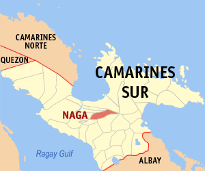
English: Map of Camarines Sur showing the location of Naga
Background of NagaThe 3rd Philippine city granted the title of 'Royal' (after Manila and Cebu) by King Philip II and the Ecclesiastical seat of the Bishop of the entire Bicol region and almost half of Southern Luzon for three centuries centuries, Naga, or formerly known as the Royal City of Nueva Caceres (New Caceres), is the Queen City of Bicol. The title of 'Queen City' is used in the context of the historical significance. For hundreds of years Naga has been the center of trade, education, religion, culture and healthcare in the region. This notion is further re-enforced since the Queen and Principal Patroness of Bicol, the miraculous image of Our Lady of Penafrancia, resides in Naga. |
| Дата | |
| Чыганак | English Wikipedia |
| Автор | Mike Gonzalez (TheCoffee) |
Лицензияләү

|
Бу документтан күчермә алырга, аны таратырга һәм/яки үзгәртергә Ирекле программалар фонды тарафыннан бастырылган 1.2 һәм соңрак чыгарышлы GNU Free Documentation License шартлары буенча хакыгыз бар, әмма үзгәрмәс бүлекләрсез, алгы һәм арткы тышлыктагы текстсыз. Лицензиянең күчермәсе GNU Free Documentation License исемле бүлеккә кертелгән. |
| Әлеге файл Creative Commons Attribution-Share Alike 3.0 Unported лицензиясе буенча рөхсәт ителгән. | ||
| ||
| Этот признак лицензирования был добавлен к этому файлу как часть обновления лицензии GFDL. |

|
If you choose to use this work under the Creative Commons license stated above, the author, Mike Gonzalez (TheCoffee), would like you to attribute the work to him (among other requirements such as indicating that the work is licensed under the Creative Commons) with the following text or similar:
© Mike Gonzalez, 2005.
His name should be a link to the Wikimedia Commons userpage TheCoffee. If a link is not possible, then the url should be placed in parentheses after the name. If the work has been substantially altered by other people (see the File history section below), then this particular attribution requirement is waived, which means you can attribute the work in any reasonable manner. This attribution requirement is provided pursuant to the Creative Commons Attribution mechanism where "you must attribute the work in the manner specified by the author or licensor (but not in any way that suggests that they endorse you or your use of the work)." (See "Attribution" in the Creative Commons website.)
|
Файл тарихы
Файлның нинди булганлыгын күрү өчен «дата/вакыт» дигәненә басыгыз.
| Дата/вакыт | Кече рәсем | Үлчәмнәре | Кулланучы | Искәрмә | |
|---|---|---|---|---|---|
| агымдагы | 25 дек 2005, 10:34 | | 300 × 250 (13 Кб) | Magalhães | Map of Camarines Sur showing the location of __. Created by TheCoffee. Released under the GNU FDL {{GFDL-en}} Category:Maps of Camarines Sur |
Файлны куллану
Әлеге файл киләсе битне куллана:
Файлның гомуми кулланышы
Әлеге файл аста бирелгән викиларда куллана:
- ar.wikipedia.org проектында куллану
- bcl.wikipedia.org проектында куллану
- cbk-zam.wikipedia.org проектында куллану
- ceb.wikipedia.org проектында куллану
- de.wikipedia.org проектында куллану
- en.wikipedia.org проектында куллану
- eo.wikipedia.org проектында куллану
- es.wikipedia.org проектында куллану
- fr.wikipedia.org проектында куллану
- gor.wikipedia.org проектында куллану
- he.wikipedia.org проектында куллану
- id.wikipedia.org проектында куллану
- ilo.wikipedia.org проектында куллану
- incubator.wikimedia.org проектында куллану
- it.wikipedia.org проектында куллану
- ja.wikipedia.org проектында куллану
- ko.wikipedia.org проектында куллану
- ms.wikipedia.org проектында куллану
- nl.wikipedia.org проектында куллану
- no.wikipedia.org проектында куллану
- pag.wikipedia.org проектында куллану
- pam.wikipedia.org проектында куллану
- simple.wikipedia.org проектында куллану
- sv.wikipedia.org проектында куллану
- tl.wikipedia.org проектында куллану
- ur.wikipedia.org проектында куллану
- war.wikipedia.org проектында куллану
- www.wikidata.org проектында куллану
- zh.wikipedia.org проектында куллану