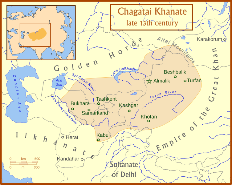
Файл:Chagatai Khanate map en.svg

753 × 600 нокта - SVG файлын беренчел карау размеры PNG. Башка ачыклык: 301 × 240 нокта | 603 × 480 нокта | 964 × 768 нокта | 1280 × 1020 нокта | 2560 × 2039 нокта | 811 × 646 нокта.
Төп файл (SVG файлы, шартлы 811 × 646 нокта, файлның зурлыгы: 468 Кб)
Файл тарихы
Файлның нинди булганлыгын күрү өчен «дата/вакыт» дигәненә басыгыз.
| Дата/вакыт | Кече рәсем | Үлчәмнәре | Кулланучы | Искәрмә | |
|---|---|---|---|---|---|
| агымдагы | 15 июл 2008, 04:50 |  | 811 × 646 (468 Кб) | MapMaster | +river name, + colour adjustment |
| 15 июл 2008, 04:13 |  | 811 × 646 (454 Кб) | MapMaster | made a few corrections to version | |
| 15 июл 2008, 04:07 |  | 811 × 646 (426 Кб) | MapMaster | {{Information |Description={{en|1=A map of the Chagatai Khanate, late 13th century}} |Source=Own work by uploader |Author=MapMaster |Date=14 July 2008 |Permission= |other_versions= }} {{ImageUpload|full}} |
Файлны куллану
Әлеге файл киләсе битне куллана:
Файлның гомуми кулланышы
Әлеге файл аста бирелгән викиларда куллана:
- azb.wikipedia.org проектында куллану
- az.wikipedia.org проектында куллану
- bg.wikipedia.org проектында куллану
- bn.wikipedia.org проектында куллану
- ca.wikipedia.org проектында куллану
- ce.wikipedia.org проектында куллану
- crh.wikipedia.org проектында куллану
- da.wikipedia.org проектында куллану
- de.wikipedia.org проектында куллану
- el.wikipedia.org проектында куллану
- en.wikipedia.org проектында куллану
- eo.wikipedia.org проектында куллану
- et.wikipedia.org проектында куллану
- fr.wikipedia.org проектында куллану
- he.wikipedia.org проектында куллану
- hi.wikipedia.org проектында куллану
- hr.wikipedia.org проектында куллану
- hu.wikipedia.org проектында куллану
- it.wikipedia.org проектында куллану
- ja.wikipedia.org проектында куллану
- kk.wikipedia.org проектында куллану
- ko.wikipedia.org проектында куллану
- lt.wikipedia.org проектында куллану
- mk.wikipedia.org проектында куллану
- mn.wikipedia.org проектында куллану
- nl.wikipedia.org проектында куллану
- oc.wikipedia.org проектында куллану
- pl.wikipedia.org проектында куллану
- pnb.wikipedia.org проектында куллану
Бу файлның гомуми кулланышын карау.