Файл:Amazon-river-NASA.jpg

Алдан карауның зурлыгы: 600 × 600 нокта. Башка ачыклык: 240 × 240 нокта | 480 × 480 нокта | 768 × 768 нокта | 1024 × 1024 нокта | 2048 × 2048 нокта | 4096 × 4096 нокта.
Төп файл (4096 × 4096 нокта, файл зурлыгы: 2,79 Мб, MIME төре: image/jpeg)
Тасвирлама
| Тасвир |
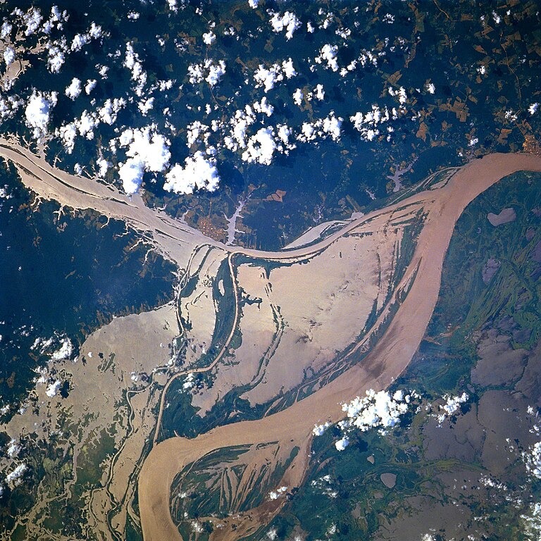
Afrikaans: STS078-751-094 Oorstroomde Amasonerivieroewers in westelike Pará-provinsie, Brasilië in Junie 1996. Die ligging is sowat halfpad tussen Manaus en die Amasonerivierdelta.
Hierdie beeld toon oorstroomde oewers van 'n klein segment van die Amasonerivier, insluitend die oerwouddorpies Oriximiná en Óbidos. Songlans op die modderige rivierwater fasiliteer die onderskeiding van land en water. Deur hierdie beeld met 'n gedetailleerde gebiedskaart te vergelyk, word dit duidelik dat die Amazonerivier sy oewers in die laagliggende dele aanliggend aan die vloedvlakte van die hoofkanaal oorstroom, en groot dele suid van die hoofkanaal staan ook onder (skoon) water. Ontbosde gebiede is binne die digbegroeide terrein aan die noordekant van die Amasonerivier waarneembaar. Die hoofkanaal van die Trombetasrivier kan suidooswaarts nagespeur word, van die linkerrand van die prent af, totdat die Trombetas tussen die oerwouddorpies Oriximiná en Óbidos met die Amasone saamvloei. English: A satellite image of a part of the Amazon River.
Esperanto: La bildo estas kopiita de wikipedia:en. La originala priskribo estas
English: Original caption: [altered to reflect rotation]
|
| Дата | |
| Чыганак | http://earth.jsc.nasa.gov/sseop/EFS/photoinfo.pl?PHOTO=STS078-751-94 (file) |
| Автор | NASA |
| Местоположение объекта | | Это и другие изображения по их местоположению на OpenStreetMap |
|---|
Это изображение или видеозапись внесены в каталог одного из исследовательских центров НАСА под идентификатором (Photo ID): STS078-751-94. Этот шаблон не указывает на правовой статус данной работы. По-прежнему необходим нормальный шаблон лицензий. См. Commons:Лицензирование. Другие языки:
|
Лицензияләү
| Этот файл находится в общественном достоянии (англ. public domain), так как он был создан NASA (Национальным управлением по аэронавтике и исследованию космического пространства). Политика авторского права NASA гласит, что «Материал NASA не защищается авторским правом, если не указано иное». (См. Template:PD-USGov, страницу политики авторского права NASA или политику использования изображений JPL.) | ||
 |
Предупреждения:
|
Old file history
Transferred from English-Wikipedia:
| date/time | username | edit summary |
|---|---|---|
| 02:26, 6 January 2005 | en:User:Quadell | (tagged) |
| 18:08, 18 June 2004 | en:User:Sverdrup | (Image info) |
| 18:06, 18 June 2004 | en:User:Sverdrup | (A satellite image of a part of the <a href="/wiki/Amazon_River" title="Amazon River">Amazon River</a>) |
| Annotations | This image is annotated: View the annotations at Commons |
Файл тарихы
Файлның нинди булганлыгын күрү өчен «дата/вакыт» дигәненә басыгыз.
| Дата/вакыт | Кече рәсем | Үлчәмнәре | Кулланучы | Искәрмә | |
|---|---|---|---|---|---|
| агымдагы | 8 дек 2022, 17:13 | | 4096 × 4096 (2,79 Мб) | JMK | boost saturation, add some contrast |
| 8 дек 2022, 17:10 |  | 4096 × 4096 (2,69 Мб) | JMK | rotate 180, north up | |
| 10 ноя 2022, 10:10 |  | 4096 × 4096 (15,22 Мб) | Askeuhd | Higher resolution version | |
| 10 окт 2012, 14:15 |  | 640 × 640 (418 Кб) | Rotatebot | Bot: Image rotated by 180° | |
| 29 гый 2006, 14:39 |  | 640 × 640 (377 Кб) | Maksim | La bildo estas kopiita de wikipedia:en. La originala priskribo estas: A satellite image of a part of the Amazon River. {{PD-USGov-NASA}} '''Original caption:''' :''STS078-751-094 Amazon River, Western Para Province, Brazil June 1996'' :''This image s |
Файлны куллану
Бу файлны кулланган битләр юк.
Файлның гомуми кулланышы
Әлеге файл аста бирелгән викиларда куллана:
- ar.wikipedia.org проектында куллану
- ast.wikipedia.org проектында куллану
- azb.wikipedia.org проектында куллану
- ca.wikipedia.org проектында куллану
- ce.wikipedia.org проектында куллану
- cv.wikipedia.org проектында куллану
- en.wikipedia.org проектында куллану
- eo.wikipedia.org проектында куллану
- es.wikipedia.org проектында куллану
- eu.wikipedia.org проектында куллану
- fa.wikipedia.org проектында куллану
- fr.wikipedia.org проектында куллану
- fy.wikipedia.org проектында куллану
- id.wikipedia.org проектында куллану
- ilo.wikipedia.org проектында куллану
- kk.wikipedia.org проектында куллану
- krc.wikipedia.org проектында куллану
- ml.wikipedia.org проектында куллану
- mr.wikipedia.org проектында куллану
- nl.wikipedia.org проектында куллану
- no.wikipedia.org проектында куллану
- os.wikipedia.org проектында куллану
- pl.wiktionary.org проектында куллану
- pt.wikipedia.org проектында куллану
- rm.wikipedia.org проектында куллану
- ru.wikipedia.org проектында куллану
- uk.wikipedia.org проектында куллану
- vec.wikipedia.org проектында куллану
- vi.wikipedia.org проектында куллану
- www.wikidata.org проектында куллану
- zh-yue.wikipedia.org проектында куллану
- zh.wikipedia.org проектында куллану