Тоба (күл): юрамалар арасында аерма
Яңа бит: «{{Диңгез |исем = Тоба күле |үзисем = |рәсем = Toba zoom.jpg |рәсем язуы = Landsat иярчене фотосурәте |өлкә = …» |
(аермасы юк)
|
5 июн 2012, 05:02 юрамасы
| |||||||||||||||

Тоба күле (индон. Danau Toba) - 2°41′04″ т. к. 98°52′32″ кч. о.HGЯO урнашкан күл һәм супер-янартау. Күл озынлыгы 100 километр, киңлеге 30 километр. Индонезияның Суматра утравының төньяк өлешенең уртасында урнашкан күл 2°53′ т. к. 98°31′ кч. о.HGЯO белән 2°21′ т. к. 99°06′ кч. о.HGЯO нокталары арасында сузыла. Индонезияның иң эре һәм дөньяның иң эре янартау күле булуы мәгълүм.[1]
Геология
Атылу

Атылу Көньяк Азияны якынча 15 см көл юрганы каплады; үзәк Һиндстандагы бер җирлегендә бүгенге көндә сакланган көл юрганы тирәнлеге 6 м[2], Малайзия кайбер урыннарында 9 м янартау көле белән капланган иде.[3] Монын өстеннән, вакыйга нәтиҗәсендә атмосферага кислота яңгырына китергән 10 000 миллион тонна күкерт кислотасы[4] [чыганагы?] яки 6 000 миллион тонна күкерт диоксиды[5] эләгүенә китергән.
Соңгы арадагы активлык
</ref>
Some parts of the caldera have experienced uplift due to partial refilling of the magma chamber, for example pushing Samosir Island and the Uluan Peninsula above the surface of the lake. The lake sediments on Samosir Island show that it has been uplifted by at least 450 m (1,476 ft)[6] since the cataclysmic eruption. Such uplifts are common in very large calderas, apparently due to the upward pressure of unerupted magma. Toba is probably the largest resurgent caldera on Earth. Large earthquakes have occurred in the vicinity of the volcano more recently, notably in 1987 along the southern shore of the lake at a depth of 11 km (6.8 mi).[7] Other earthquakes have occurred in the area in 1892, 1916, and 1920–1922.[6]
Lake Toba lies near the Great Sumatran fault which runs along the centre of Sumatra in the Sumatra Fracture Zone.[6] The volcanoes of Sumatra and Java are part of the Sunda Arc, a result of the northeasterly movement of the Indo-Australian Plate which is sliding under the eastward-moving Eurasian Plate. The subduction zone in this area is very active: the seabed near the west coast of Sumatra has had several major earthquakes since 1995, including the 9.1 2004 Indian Ocean Earthquake and the 8.7 2005 Sumatra earthquake, the epicenters of which were around 300 km (190 mi) from Toba.
On 12 September 2007, a magnitude 8.5 earthquake shook the ground in Sumatra and was felt in the Indonesian capital, Jakarta. The epicenter for this earthquake was not as close as the previous two earthquakes, but it was in the same vicinity.-->
2010 елның 26 октябрь көне Индонезияның Пагай-селатан утравының 36 км көньяк-көнбатышта 3 м бөеклектә цунами тудырган 7,7 дәрәҗәсендә җиртетрәве урын алды.
2012 елның 10 гыйнварында регионда 7,3 бөеклеге җиртетрәве урын алды.
Атылу мөмкинлеге
GRACE иярчене күрсәткәненчә, Суматра утравы тирәсендәге 2004 елгы җиртетрәве[8] Җир шарының формасын үзгәртте[9]. Якын тирәдә соңгы арада урын алган җиртетрәүләре бу колоссаль климат-үзгәртүче магма активлыгын башлата алуы мөмкин.


Кешеләрe
Флора һәм фауна
Gallery
-
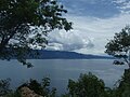 Парапаттан Тоба күле күренеше
 -
 Амбаритадан Тоба күле күренеше
 -
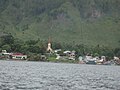 Самосир Тоба күле авыллары
 -
 Парапат лиманы
 -
 Батак авылы
 -
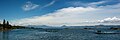 Күлнең Симаниндодан күренеше


Шулай ук карагыз
Искәрмәләр
- ↑ Worldlakes.org
- ↑ (1993) «Toba ash on the South Asia and its implications for correlation of late pleistocene alluvium». Quaternary Research 40 (1): 10–19. DOI:10.1006/qres.1993.1051.
- ↑ Scrivenor, John Brooke (1931). The Geology of Malaya. London: MacMillan. ., noted by Weber.
- ↑ (2001) «Cooling of the South China Sea by the Toba Eruption and correlation with other climate proxies ∼71,000 years ago». Geophysical Research Letters 28 (20): 3915–3918. DOI:10.1029/2000GL006113.
- ↑ (2009) «Did the Toba volcanic eruption of ~74k BP produce widespread glaciation?». Journal of Geophysical Research 114: D10107. DOI:10.1029/2008JD011652.
- ↑ 6,0 6,1 6,2 Toba, Sumatra, Indonesia. Oregon State University.]
- ↑ Significant Earthquakes of the World. United States Geological Survey (USGS).
- ↑ Gross, Richard (October 2005). The Gravitational Signature of the December 26, 2004 Sumatran Earthquake. University of Texas Center for Space Research. December 2011 тикшерелгән.
- ↑ Satellite Data Reveals Gravity Change From Sumatran Earthquake, Ohio State University Research News (August 2006). 1 декабрь 2011 тикшерелде.
Өстәмә әдәбият
- Rampino, Michael R. and Stephen Self (1993). «Climate-volcanism feedback and the Toba eruption of 74,000 Years Ago». Quaternary Research 40 (3): 269–280. DOI:10.1006/qres.1993.1081.
- Vazquez, Jorge A. and Mary R. Reid (2004). «Probing the accumulation history of the voluminous Toba Magma». Science 305 (5686): 991–994. DOI:10.1126/science.1096994. PMID 15310899.
- Petraglia, M. et al. (2007). «Middle Paleolithic Assemblages from the Indian Subcontinent Before and After the Toba Super-Eruption». Science 317 (5834): 114–116. DOI:10.1126/science.1141564. PMID 17615356.
Сылтамалар
- Toba, Sumatra, Indonesia – Volcano.umd.edu Accessed 11 December 2005 Калып:Dead link
- Stanley H. Ambrose, Volcanic Winter, and Differentiation of Modern Humans Accessed 11 December 2005
- Joel Achenbach, Who Knew, National Geographic Accessed 11 December 2005
- George Weber, Toba Volcano
- (Lake Toba Ecosystem Management Plan) From laketoba.org
- Калып:Wikitravel